
Hot weather through mid-week, then cooler by the end of the week. Heat Advisory from 11 AM Monday to 11 PM. Thursday Isolated mountain thunderstorm chances will persist through early this week, with some potential (10-20% chance) for these storms to impact the foothills into Monday. Discussion As of 12pm, satellite is currently showing mid […]
National Weather Service Sacramento CA
Posted inRegional
Isolated mountain thunderstorms Today-Tuesday
Moisture from Eugene will be working into NorCal creating isolated mainly mountain showers and thunderstorms starting today through early next week. Temperatures will slowly warm over the weekend and into next week. Discussion Cool start to the day with some cloud cover will keep temperatures lower today especially over the southern half of the forecast […]
Posted inRegional
Mountain Thunderstorms Possible Friday-Early Next Week
Near to slightly below normal high temperatures expected through Saturday, then above normal Sunday into early next week. Isolated thunderstorms possible over the mountains Friday into the weekend. Best potential for thunderstorms will be over the weekend, especially over the Sierra and southern Cascades. Discussion Heights/thicknesses forecast to trend down today into midweek as upper […]
Posted inRegional
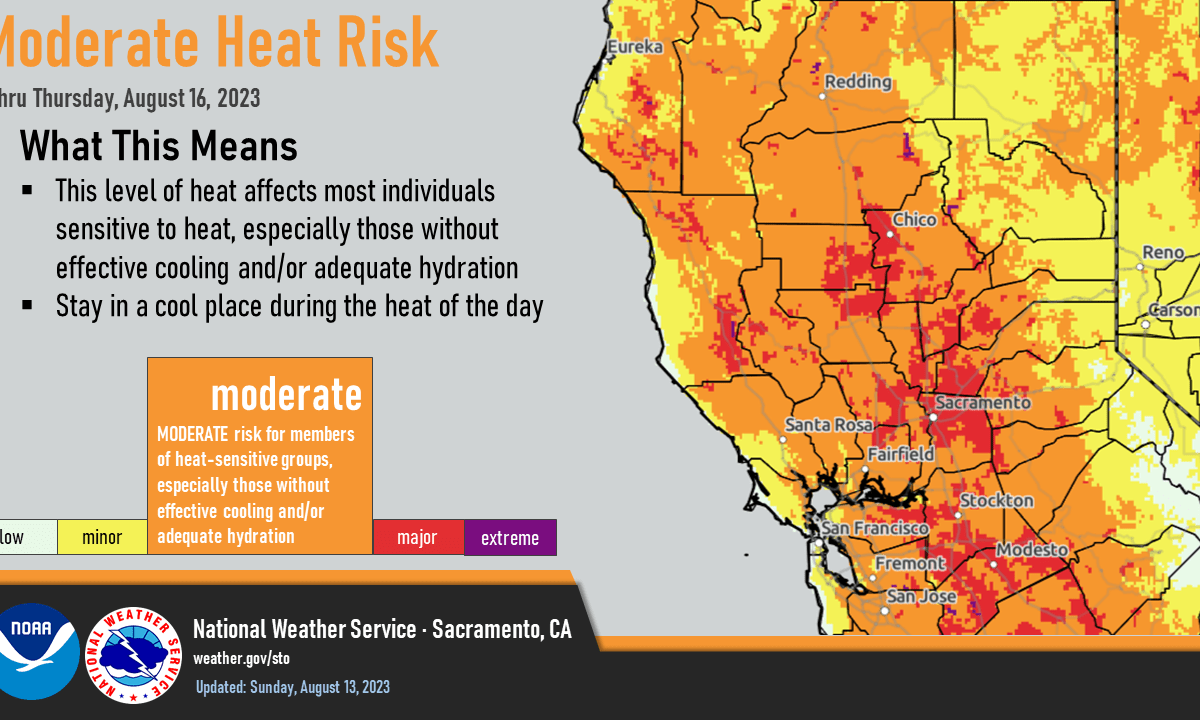
Isolated mountain thunderstorms Wednesday & Friday, then Widespread Moderate Heat Risk
Another day of warm and dry weather today, with locally elevated fire weather conditions over the northern Sacramento Valley and northeast foothills. Slight chance (10-20%) for thunderstorms Wednesday afternoon/evening and again Friday, generally along and east of the crest. Temperatures cool to near to below normal Tuesday through Thursday before a warming trend takes hold […]
Posted inRegional
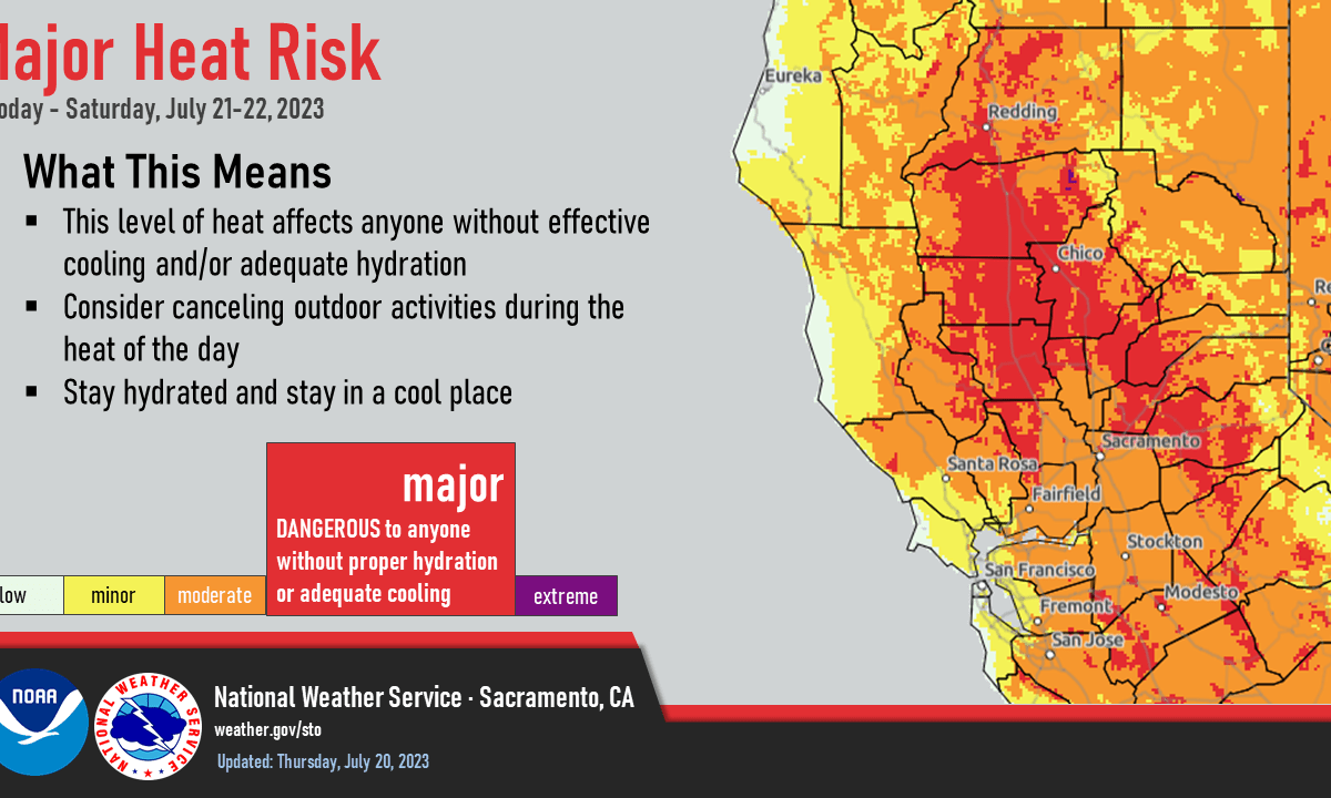
Major Heat Risk today and Saturday
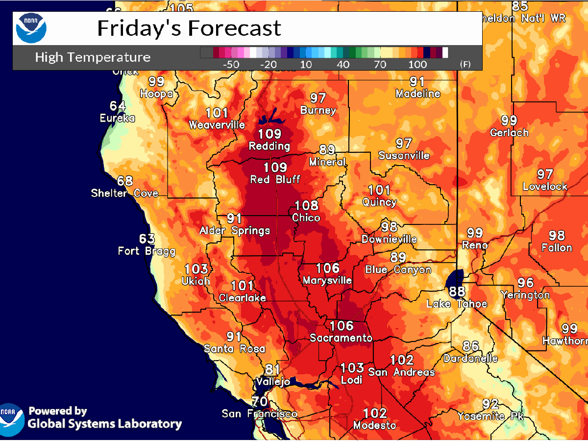
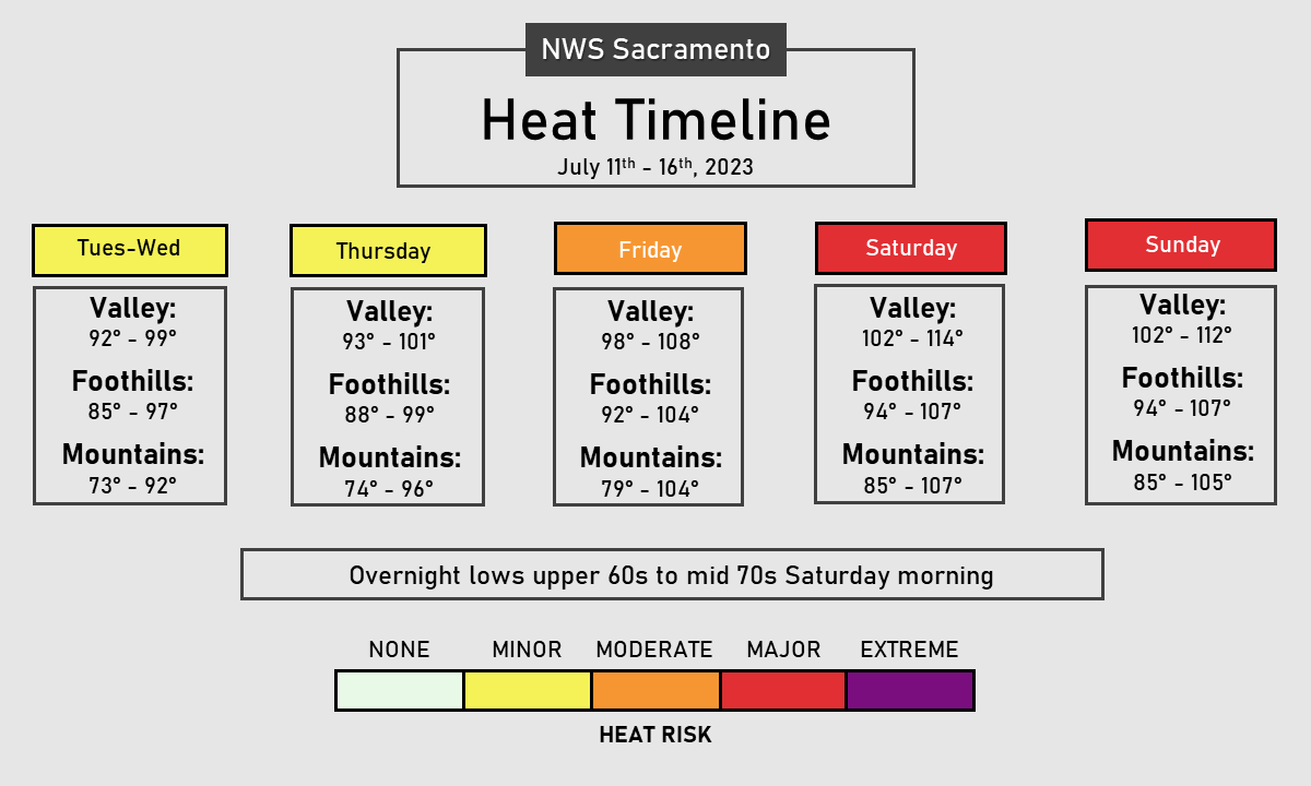
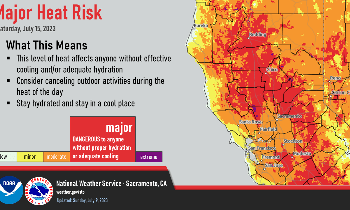
Hot and dry weather through the weekend. Temperatures will peak on today and Saturday with areas of Major Heat Risk. Heat Advisory in effect 11 AM Friday until 11 PM Saturday. Dry fuels and very low humidity may lead to easier fire starts. Areas of breezy southwest winds in the afternoon and evening. Not as […]
Posted inRegional
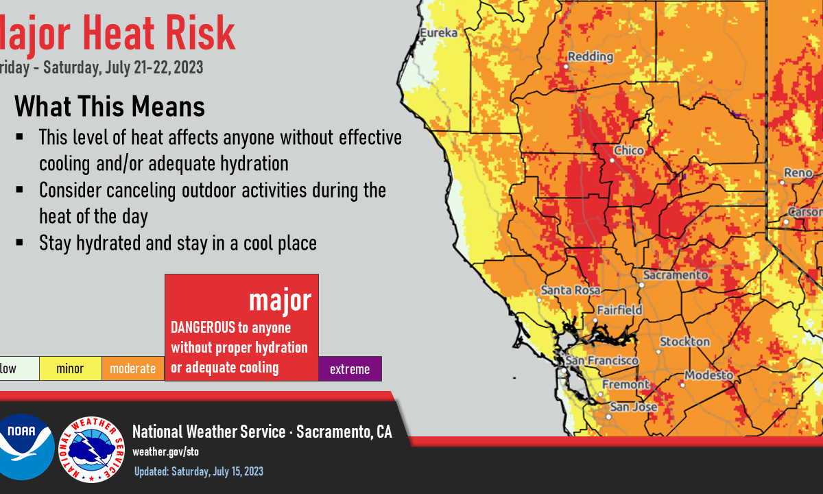
Late week warming trend will bring areas of Major Heat Risk Friday and Saturday
Hot and dry weather expected into next week. Temperatures will be increasing to well above average on Friday and Saturday. Discussion Clear to partly cloudy skies cover the region early this morning. A few thunderstorms have been ongoing across eastern Tuolumne County since late Tuesday evening as a weak disturbance moves across central California. The […]
Posted inRegional
Widespread moderate heat risk this week
Not quite as hot this week with temperatures briefly returning to near normal during the middle of the week before heating up again late in the week. Late week warming trend will bring areas of Major Heat Risk Friday. Discussion Leftover MCV (originating from the large thunderstorm complex over Sonora (northern Mexico) on Friday evening) […]
Posted inRegional
Major Heat Risk today and Sunday
Hot weather this weekend with widespread Major Heat Risk. Elevated fire weather conditions for the Valley and foothills thru Monday. Abnormally warm temperatures are likely to persist into next week. Discussion Skies are clear across the region. IR difference imagery shows stratus along the coast, but profilers indicate its quite shallow, especially north of the […]
Posted inRegional
Widespread Major Heat Risk this Weekend
Dry and increasingly hot weather into this weekend with widespread Major Heat Risk. Temperatures will trend less hot next week, near normal by mid week. Excessive Heat Warning from 11 AM Saturday to 11 PM PDT Sunday. Discussion Temperatures will be noticeably warmer today as high pressure ridging over the Desert Southwest extends westward with […]
Posted inRegional
Elevated fire weather conditions for the Valley and foothills Friday-Monday
Dry and quiet weather will continue through the end of the week into the weekend. Temperatures across the middle of the week will hover around seasonal normals, before hot, above normal temperatures arrive from Friday through Monday. Resultant widespread Major HeatRisk is forecast across the weekend ahead, alongside elevated fire weather concerns. Discussion (Today through […]
Posted inRegional
Widespread Major Heat Risk this Weekend
Dry and breezy weather with slightly below normal temperatures prevail today. Then, a significant warming trend is anticipated from the middle of the week through the upcoming weekend, with widespread moderate to major heat risk forecast for Saturday and Sunday. Discussion An upper level trough will continue to progress east-northeastward through the Pacific Northwest throughout […]
Posted inRegional
Increasing temperatures through the week
Dry, cool and breezy at times with below normal temperatures through Monday due to onshore flow. A significant warming trend next week with hot weather returning. Abnormally warm temperatures are likely to persist into the following week. Discussion The weak trough that has been sitting just off shore over the Eastern Pacific the past several […]
Posted inRegional
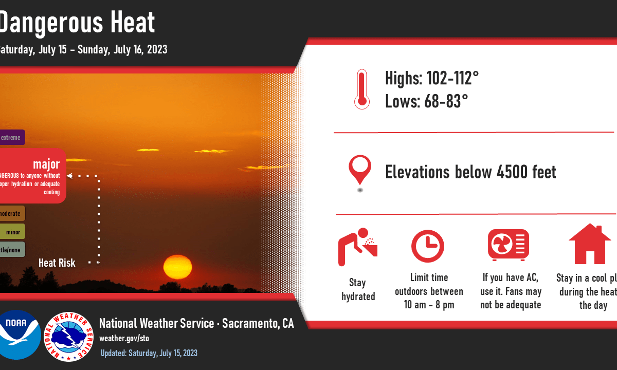
Major Heat Risk through the Weekend
Excessive Heat Warning from 11 AM Friday to 11 PM PDT Sunday. Hot and dry conditions will continue through the weekend with the region’s first widespread heatwave of the season. Peak heat expected Saturday, then will gradually moderate for the Independence Day holiday into late next week. Discussion The trough which brought below normal temperatures […]
Posted inRegional
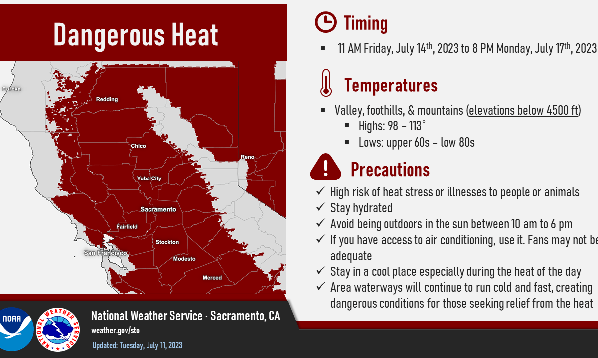
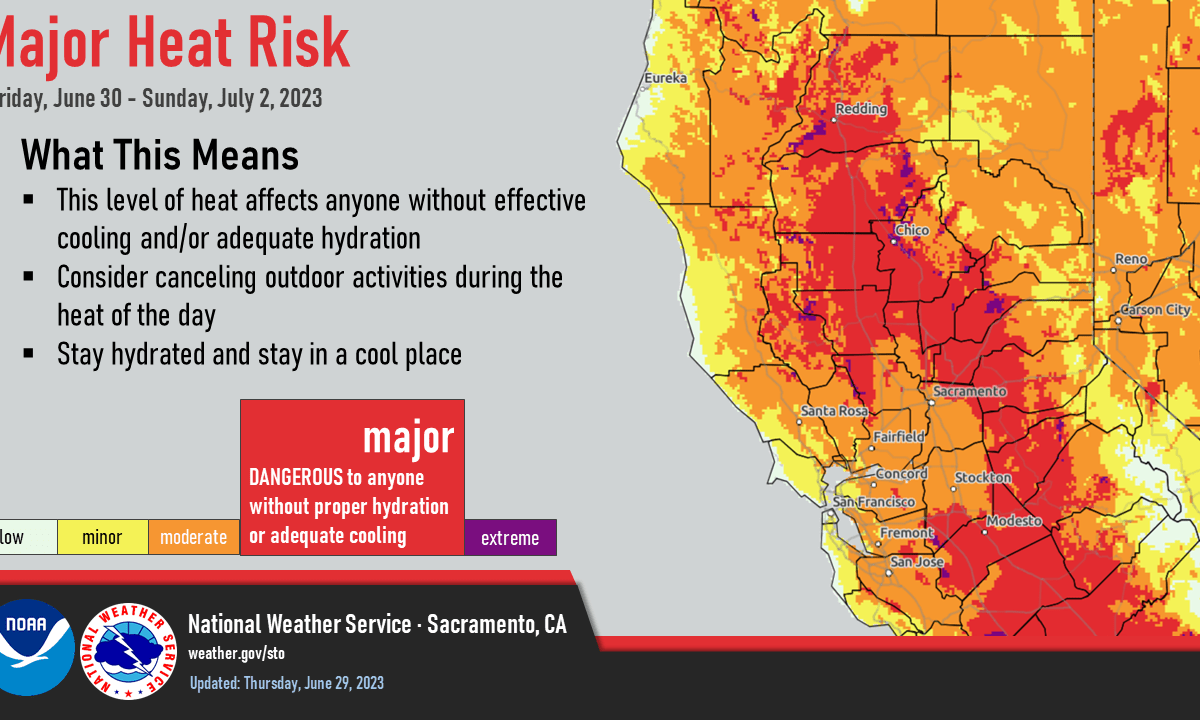
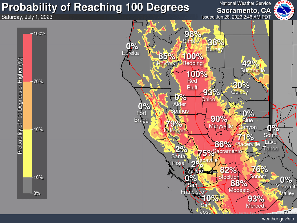
Major Heat Risk Develops Late Week and through the Holiday Weekend
Dry conditions except for a few showers and thunderstorms over the mountains today. Hot and drier weather returns Thursday and persists through the holiday weekend. Excessive Heat Watch in effect from Friday morning through Sunday evening. Major Risk for heat-related illnesses for pets, livestock, and much of the population, especially anyone without effective cooling and/or […]
Posted inRegional
Major heat risk develops late week
Dry conditions except for a slight chance of showers and thunderstorms over the mountains early this week. Drier conditions and hot weather returns by the middle of the week, becoming increasingly hot for the 4th of July holiday weekend. Discussion Skies are mostly clear across the region early this morning except for a few clouds […]
Posted inRegional
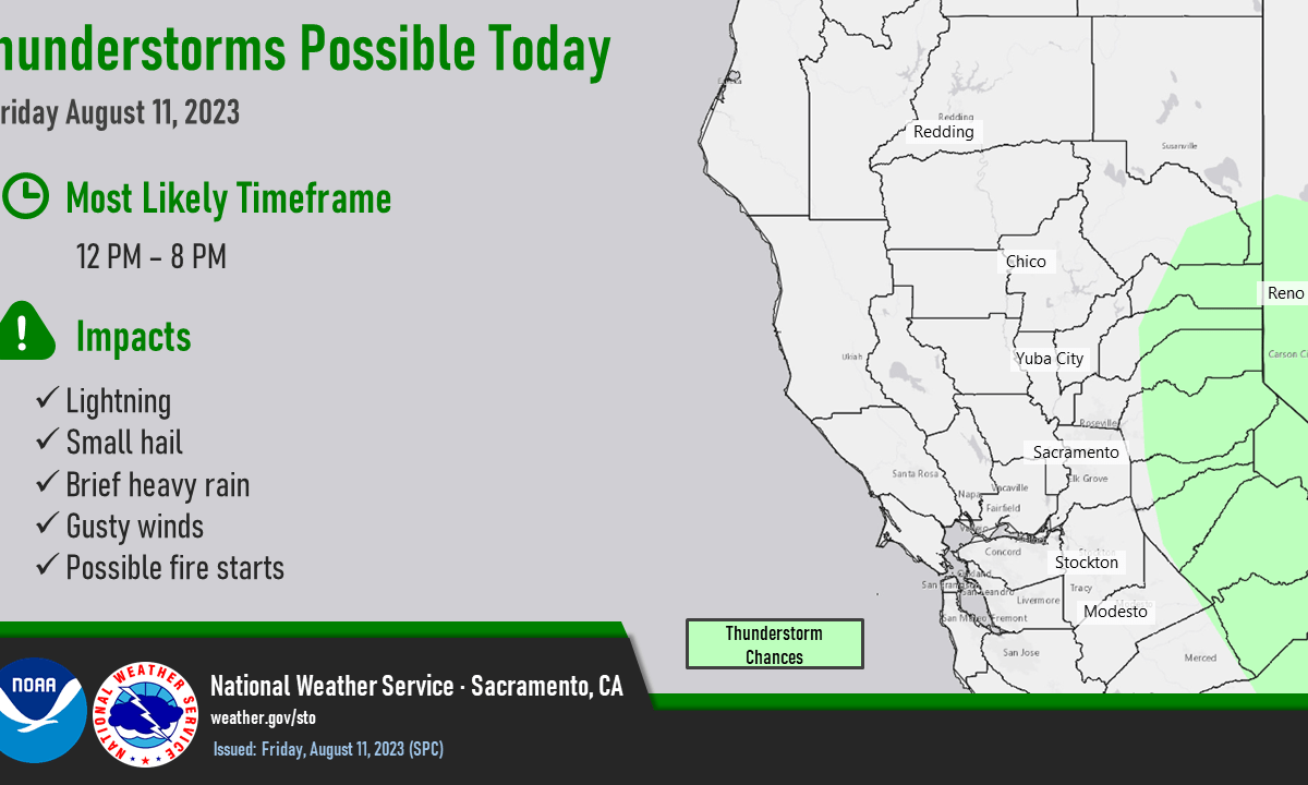
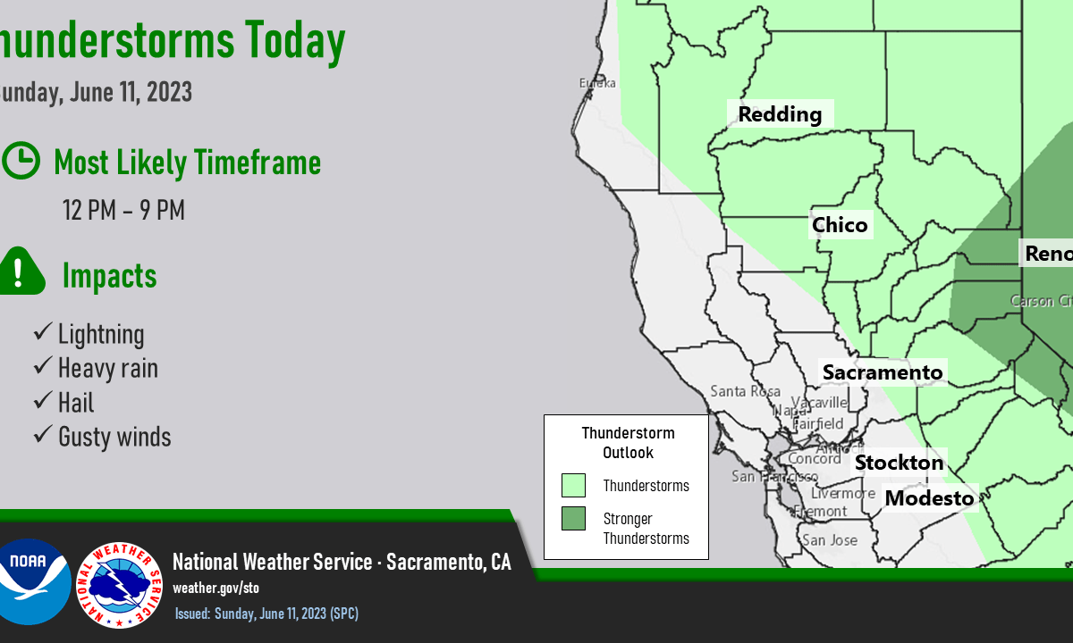
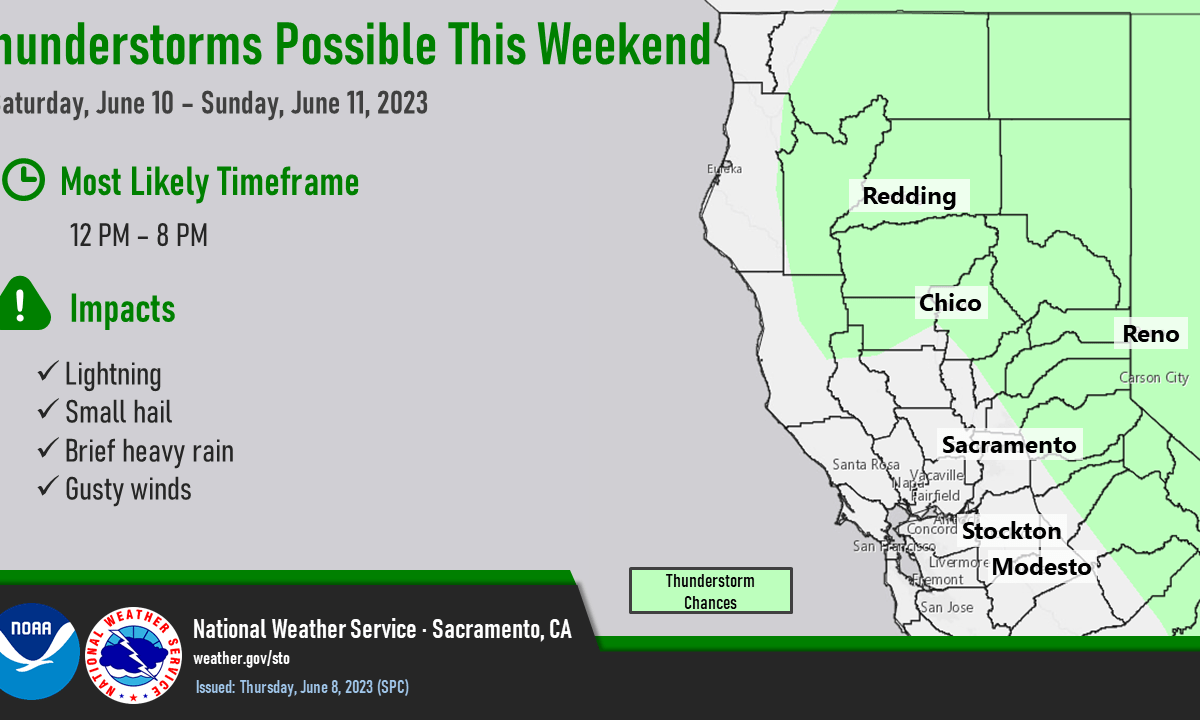
Scattered Thunderstorms Today – Monday
Most widespread thunderstorm chances today-Monday, then limited to the mountains the rest of the week. Afternoon and evening thunderstorms the next several days. Temperatures will remain below normal then start increasing to near to slightly above normal by mid-week. Discussion Partly cloudy skies cover the region early this morning. Radar shows only a few light […]
Posted inRegional
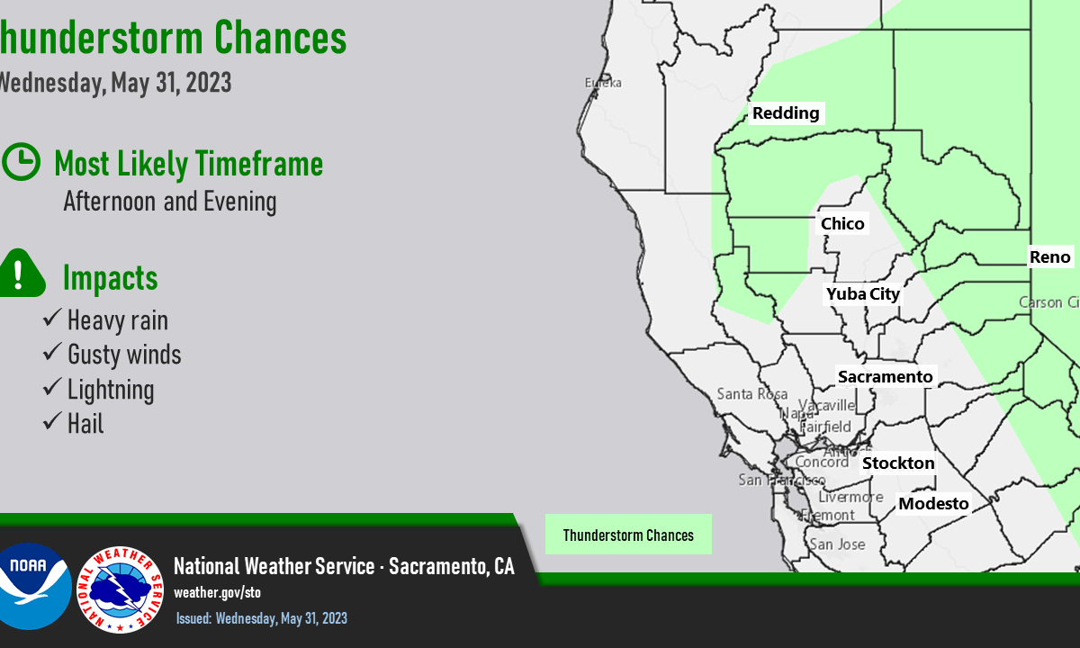
Scattered daily mountain thunderstorms
Isolated to scattered showers and thunderstorms possible over the next week, primarily in the mountains. More widespread thunderstorms possible over the weekend and Monday, including isolated Valley thunderstorms. Continued near or below normal temperatures for the foreseeable future. Discussion Latest satellite imagery and observations shows a weak low pressure system broadly circulating across northern NV/southeastern […]
Posted inRegional
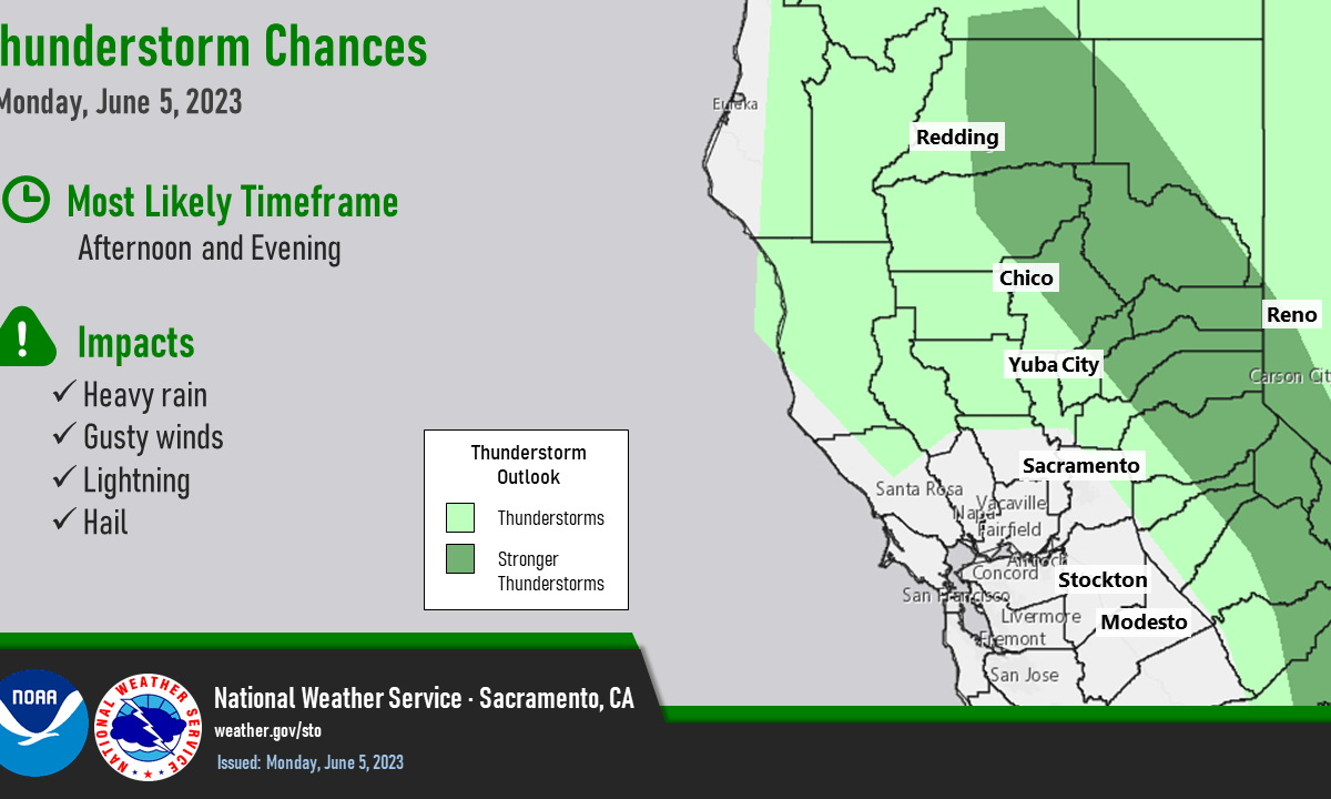
Increased chances of thunderstorms early this afternoon
Shower and thunderstorm chances become more extensive through midweek. Temperatures cooling to below average by Tuesday. Isolated to scattered thunderstorms may produce heavy rain, dangerous lightning, gusty winds and hail impacting outdoor activities and recreationists. Heavy rain from stronger storms may lead to localized flooding and increased travel times. Discussion Satellite imagery shows clouds continuing […]
Posted inRegional
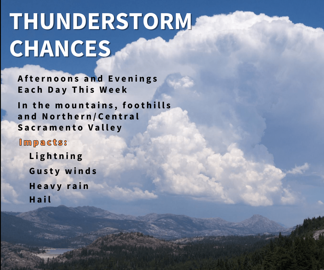
Isolated to scattered afternoon/evening thunderstorms each day
Shower/thunderstorm chances over the mountains today, then become more extensive beginning Monday. Temperatures will be above average today, then cooler weather returns. Discussion Skies are mostly clear across interior NorCal early this morning. Debris cloudiness from Saturday’s convection in the Sierra is moving north along the Nevada border. High pressure over the region is resulting […]
Posted inRegional
Isolated to scattered afternoon/evening thunderstorms each day
Shower and thunderstorm chances will retreat to the northern Sierra the rest of the week. Temperatures will return to above average by the weekend. Discussion Clear to partly cloudy skies cover the region as we’re between the closed low moving through SoCal and a series of short-waves passing to the north through the PacNW. Onshore […]